Sulphide Creek Gold-Antimony Project
- Sulphide Creek Gold-Antimony Project1 (EL16/2022) is located in Tasmania’s world-class Queenstown mining district
- Multiple gold targets along 6 km of strike, tracking a major structure which has been under-explored to date
> Historical workings contain up to 14g/t Au
> Antimony workings with notable 60-70% Sb high grades - Multiple mineralisation models to explore and develop; with orogenic Victorian Beaconsfield-style or Henty-style targets
- Historic exploration modelling and work confirmed by AUH geologists suggest potential for a large gold Au system at Sulphide Creek project.
- Opportunity to develop compelling model for high grade antimony targets with modern exploration techniques
1AUH ASX announcement 26 May 2025 – “Investor Presentation May 2025”
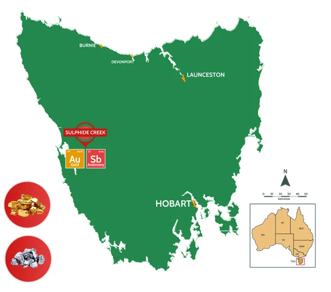
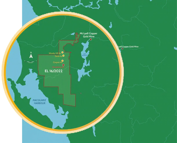
SULPHIDE CREEK PROJECT
Located in prolific historical mining area of Western Tasmania
- Project is 5km south of Queenstown mining centre and Mount Lyell Mine – good access to road, power, water and workforce
- Granted tenure (EL16/2022) covering 224km² located dominantly within crown land or timber production zone – good land access
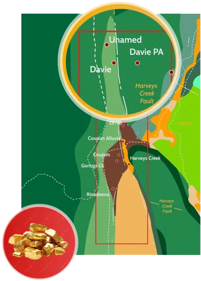
Multiple Target areas: Rinadeena (Sb)
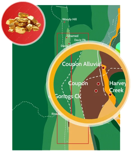
Coupon (Au)
24-28 Anomaly (Au)
Davie (Au) and Davie PA (Au)
SULPHIDE CREEK GEOLOGY
- Project lies on western margin of the Mount Read Volcanics within the Dundas stratotectonic element, with lower greenschist metamorphism and deformation linked to the Devono-Carboniferous Tabberabberan Orogeny.
- The geology consists of three structurally bound zones:
> Western half: Ordovician–Devonian marine clastics, divided by the N-S striking Harvey Creek Fault (HCF).
> Northeast: Similar clastics with substantial Gordon Limestone thicknesses east of the HCF.
> Southeast: Cambrian Tyndall Group volcano clastics fault-bounded and unconformably overlain by Ordovician Gordon Limestone, juxtaposed with Cambro-Ordovician clastics and conglomerates. - Main target area is transected by the HCF and related secondary structures. Gold mineralisation is low-grade, structurally controlled and hosted in gold-arsenopyrite-pyrite quartz vein stockworks within Lower Ordovician Rinadeena Formation siliciclastics near the HCF.
- Mineralisation is associated with significant silica and sericite alteration. Geological interpretation remains uncertain, and historical exploration may have been ineffective.
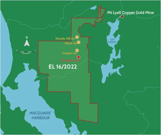
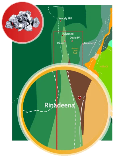
RINADEENA ANTIMONY PROSPECT
- Only historic antimony occurrence recorded by Geological Survey of Tasmania that is accessible. Ore samples collected and stored by the Geological Survey of Tasmania.
- Antimony is on the critical mineral lists of many countries including; Australia, the USA, Canada, Japan and the EU due to its defence and military applications.
- Reported from workings (1906-1907) of very high grade – ranging from 50 to 70% Sb in stibnite (and 5 to 9 g/t Au) in lode-hosted 6m width structure along slate and quartzite contact.
- Tasmanian Geological Survey reports assays taken from Mines Inspector reported to contain upto 66.57% Sb and 1.05% Pb.
- The Rinadeena Formation is lithologically, structurally and stratigraphically equivalent to the host rocks of the million-ounce Beaconsfield deposit in Victoria.
- Records suggest 41m horizontal adit, from a 4m vertical shaft (no production records available).
- Prospect has had no modern exploration – discovery potential exists with modern exploration techniques.
COUPON GOLD PROSPECT
- Reported at least six tunnels plus shafts and winzes were developed historically into gold-bearing limonitic zones. Production records in 1913 indicate 32t of ore was extracted at recovered grade of 12 g/t Au.
- Comprehensive channel sampling returned several significant gold zones including; 5m at 5.76 g/t Au, 8 m at 2.32 g/t Au, 25m at 2.00 g/t Au and 10m at 1.45 g/t Au. (Perilya, 1991)
- Historic Au-As anomalism in soils extends ~400m by 50m outside current known workings, not as yet tested.
- Previous drilling at Coupon was limited and did not reach target, but one hole has recovered 24m @ 1.1 g/t Au from 16m (Cyprus, 1989).
- Later drilling by Goldsteam in 1995 showed anomalous Au-As, but only one sample > 1 g/t Au.
- Rock chip sampling along major east trending fault (which was not drilled) returned > 1 g/t Au along 100m strike. Goldsteam suggest early drilling potentially in the wrong direction (Goldsteam, 1995). Drillhole testing this new theory intersected 8m @ 1.24 g/t Au (from 70m).
- No exploration testing of Coupon since 1995 – assessed as significant exploration opportunity for AUH.
DAVIE and DAVIE PA GOLD PROSPECTS
- Historic records suggest Davie PA (separate mining area 500m west of Davies) consisted of a 150m main drive developed on northerly-striking haematitic sandstone and gold-bearing agglomerate /breccia, with higher grade shoots in narrow westerly quartz reefs (14 to 150 g/t Au). Limited information and unexplored to date.
- Records of the main Davie workings appeared to consist of several shafts and adits developed on quartz reefs which recorded 14 g/t gold at surface. Minor sericite is apparent locally and arsenopyrite and pyrite are disseminated throughout the sandstone below 75m.
- Faulted Fe-rich breccia/veining identified at surface.
- Surface sampling shows significant Au-As halo around previous working, with 400m by 100m in soils and grab samples up to 14 g/t Au (Cyprus, 1989).
- Limited drilling at Davies Prospect has thick zone of low-grade mineralisation with 82m @ 0.4 g/t Au from 44m (SCDDH2) in vein stockwork system (Zinico NL, 2005).
- Drilling by Shree (2010) identified more low-grade, but significantly thicker intersections, with significant sericite and pervasive silica alteration and FeO-Quartz stockwork veining.
